ARCHITECTURE &
ENGINEERING


Horizontal Investigation of the Complex Adaptive System
Volume
Void
By analyzing the volumes in the choosen study area and categorizing them based on their heights, at the first glance we understand two point. First the shape of blocks and buildings, we can easily see how the morphology changes from homogeneous combination between volumes and voids to heterogeneous combination on the Ex-Macello and its east side. Second in the study area we see diversity in the height of the buildings mostly from 5 to 25 meter changes but as we reach to the east part almost all the volumes are in the 5-15 category
From the void analysis of the area we see that our site of project is not weel connected with system of voids of the district, it is mostly made of asphalt surface which increase surface temperature and intensify heat island effect. the small greenaries that exist is not connected to the green ray n.3 of milan and are isolated from surrounding. so one of our main attempt would be decreasing from these traffic area and add to green spaces and creat a well connected green space system.

Links
Types of uses
The only public transportation line exist in east Calvairate area is placed in via Lombroso and there is not much enough streets that can host new public transportation lines. only two main streets, via Gaspare Vismara which ends at the point it reachs to via Lombroso. The rest of the study area is quite well covered and connected in terms of system of streets and public transportations. What we can do to improve the existing situation is to rearrange the street network and propose more links in the site of our project.
The existing situation is mostly abandoned buildings

Vertical Investigation
Population

Effectiveness
In analysis of public transportation effectiveness we put two maps of public transportation isochrones (5minutes for bus and tram and 10 minutes for train) the we took the intersection of most populated area with most concentrated public transportation isochrones with high level of effectiveness of public transportation since people would use it as their major means for their displacement. Since our site is an abondoned area we can see there is no demand for existing public transportation so the effectiveness level is very low.

Interface
In the existing situation which we have the via Molise which is beside our site as one of the highest integrated streets, but except that the other streets around site has lower integration and we should take this also to account that there are not much street in the east site to be analyzed from interface point of view.

Permeability
The permeability analysis shows how much this area lets the urban traffic to flow inside it. In our analysis we found permeability one of the weakest key categories in the Ex-Macello area and its east side. Presence of big blocks without any street or alley made a huge boxes that people can only walk around it and cannot even understand what is going on there. This can be one of the main causes that contributed to the failure of this site and decrease its functionality.
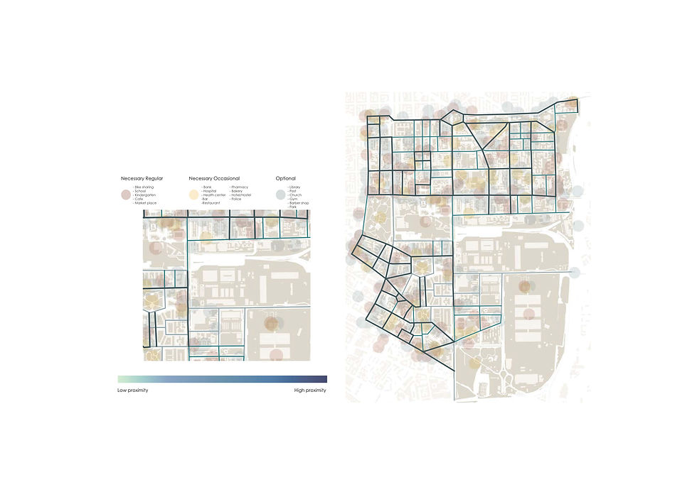
Proximity
Proximity analysis shows us in a street how much there is this chance and possibility to face an urban public function. we categorized these functions in three types of necessary regular, necessary occasional and necessary optional and showed them in order with red, yellow and blue circles on the map. The streets that would have more concentration and overlap of these circles have a higher level of proximity. As you can see we have lack of urban functions in the east part of Calvairate region.

Diversity
The method we used for analyzing the diversity level is firstly we identified all the functions that would take place in necessary regular category in red dot and made 3 minutes by walk isochrone from this points which is shown in light pink. Then we divided the occasional and optional functions in two portions, the ones that are inside these 3 minutes isochrone, the yellow dots, and the ones that are out of it, the blue dots. wherever we have more concentration in red and yellow dots we have a higher level of diversity and vice versa. In the site of our project, it is very low since it is mostly abandoned buildings which are under regeneration plans.

Porosity
The porosity analysis determines the density and compactness of the study area. as much as an area be denser it has less level of porosity. the site of our project has a high level of porosity which seems that should be a good point, but the problem is that the level of quality of these porous spaces are very low and they do not have any specific functions. They are just vast area of asphalt. So, working on the quality and network of these porous areas will be one of our main concerns in the following sections.

Accessibility
The accessibility of the study area is in a good condition, we see that almost all of it is covered at least by one of the public transportation means and in many areas there are lots of overlaps between them. The things we need to take into account is whether there are enough public transportation means at Ex-Macello area after regeneration and population increase or not. also lack of bike sharing stations can be one of the things that can be worked one and improved.